

This brief compares the Northwest Passage and the Northeast Passage with each other, and with the traditional southern shipping routes through the Suez and Panama canals and the Cape of Good Hope. It argues that the Northeast Passage, particularly Russia’s Northern Sea Route, is currently more navigable and commercially promising because of lower ice concentration, stronger infrastructure, deeper ports and greater state investment. However, both Arctic routes still present major disadvantages, including short navigation seasons, higher insurance and crew costs, the need for specialized vessels, icebreaking fees and limited port networks. Although Arctic routes can reduce distances for certain journeys between Asia, Europe and North America, they are not yet cost-effective enough to challenge the established southern routes. Their future viability will depend mainly on declining sea ice, longer navigation periods and infrastructure development, while their present importance remains largely strategic and geopolitical.
Introduction
Both the Northwest Passage (NWP) and the Northeast Passage (NEP) are showcased as new opportunities for global shipping and reducing shipping time compared to traditional routes through the Suez and Panama canals. Given the repercussions of climate change on the Arctic region, a growing number of experts envision that the NWP, through the Canadian Arctic Archipelago, and the NEP, along the Arctic coast of Eurasia, could shorten sailing distances for certain journeys between Asia, Europe and North America. However, shorter distances do not necessarily mean cheaper or more reliable shipping. Beyond their starting points via the Bering Strait and the Chukchi Sea, they differ significantly. It is interesting to see the current reality. The commercial viability of these routes depends on the sea-ice’s coverage, open navigation seasons, infrastructure and rules concerning their accessibility and usage, all of which differ significantly between the two. Also, it is important to note Canada’s and Russia’s approaches to sovereignty and regulation vis a vis the passages, because they shape the conditions under which shipping companies can use each passage. This brief examines how these differences affect the routes’ commercial prospects. Firstly, it argues that the NEP offers greater commercial potential than the NWP, but on a second note, both passages face structural problems that render them unable to compete with the established Southern Sea Routes.
Arctic Connectivity via the new maritime routes has caught the eyes of many Arctic and non-Arctic stakeholders, from states and international organizations to shipping and extraction companies. This attention is partially explained by the possibility that those Arctic routes could break the monopoly of the Southern Sea Routes. The traditional southern maritime routes are the Suez Canal Route (SCR), the Panama Canal Route (PCR), and the Cape Route. Based on the literature, the NEP is viewed as a competitor to the SCR, while the NWP is compared with the PCR. Numerous forecasting models have been conducted to assess the cost-effectiveness of the new Arctic passages in comparison to traditional routes, taking into consideration various variables and different scenarios concerning sea-ice extent and destinations. Nevertheless, it is extremely difficult to use up-to-date data since the prices, fees and climate models change constantly. This brief focuses on the most important variables and the cumulative results of relevant research to compare the Arctic Sea routes with each other and with the traditional Southern Sea routes.
Comparing the NWP with the NEP
Regarding the geographic characteristics of the Arctic Sea routes, the NWP consists of an archipelago, where ice unites the various islands for most of the year and divides them when the ice melts during a brief summer period. The NEP consists of a coastal line above the Russian Arctic (Dean 2025, 3). As a result, the NWP contains many more turns and routes than the NEP, thus rendering it more difficult to navigate. As far as the climate is concerned, although both routes are located in the Arctic climate zone, the weather conditions vary significantly. The NWP is not subjected to the warm Gulf Stream (a warm ocean current that flows from the Gulf of Mexico to the southeast coast of Newfoundland and then to North Europe), whereas the European part of NEP receives a large branch of the Gulf Stream that flows across the Atlantic to northwest Europe. Therefore, sea ice concentration is lower and easier to break in the European part of NEP.
The ports of the European Arctic remain open almost all year round, contrary to the NWP’s ports. Additionally, some parts of the NWP may be unnavigable even in the summer period, due to remaining ice concentration or accumulated ice floes from the Arctic Ocean’s currents (Dean 2025, 4). Consequently, the ships need to conduct various demanding manoeuvres to avoid the ice, rendering the NWP a riskier passage. According to climate models, the increase in the NWP’s navigability period is significantly smaller in comparison to the NEP projected opening period this century (Khon et al. 2010, 763). By the end of the 21st century, the best models, regarding navigation, predict that the NEP’s opening period will increase from 3 to 6 months, while the NWP’s period will grow from 2 to 4 months. From a physical and climate perspective, the NEP seems to be easier to navigate than the NWP.
More differences can be traced in the administration of the Arctic routes. On the one hand, Canada claims full sovereignty over the Canadian part of the NWP, asserting that it belongs to Canada’s internal waters within the Canadian archipelago. Ottawa projects sovereignty rights indirectly through environmental regulation in the NWP, like the Arctic Waters Pollution Prevention Act (AWPPA) for the prevention of sea pollution, which is stricter than the International Law of the Sea (Zou & Huang 2015, 128-129). Moreover, the NWP lacks basic infrastructure, deep-sea ports and monitoring capabilities; there is no extensive industrial activity, and it is governed by a decentralized authority system. In particular, initial Canadian strategies disregarded the NWP’s development; they mainly focused on sovereignty rights. Only the latest policies have emphasized NWP’s shipping and development.
In contrast, the development of the Northern Sea Route (NSR) and its utilization as a global maritime route were stated in the first Russian Arctic strategies. Moscow has funded numerous Arctic projects and expanded the NEP’s infrastructure considerably. According to the Kremlin, some parts of the NSR are national waters, while others are international, though Russian legislation was made obligatory unilaterally for the whole route. For example, reporting is compulsory for all ships, and foreign ships sometimes pay high fees for icebreaking and monitoring coverage depending on the ship’s permits and ice-class specifications (Zou & Huang 2015, 130). In the NSR, the ships that do not comply with the environmental regulations pay an extra fine, whilst in the NWP, they are ultimately forbidden. Another difference is the granting of access permits; Canada has never denied entry, whereas Russia has issued more than 70 rejections by 2013 (Zou & Huang 2015, 131-132). The NEP passes through deep ports, industrial plants, observation points, and its NSR part is governed by a central authority system in Russia.
Lastly, Moscow started investing in the NSR at least one decade before Canada did in the NWP. The Kremlin planned a comprehensive strategy for the development of the NSR, and it has a dual-use for this route, a military and an economic one. Foreign investments in the NSR are far greater than in the NWP, and more shipping traffic is observed in the NSR in comparison to the NWP. Based on the above, the NEP is more sustainable financially, easier to navigate and safer than the NWP. The climate models and the geography make the NEP more attractive to international shipping than the NWP.
Comparing the Arctic Maritime Routes with the Southern Sea Routes
Figure 1: Arctic Routes and Southern Routes (Gray 2025)
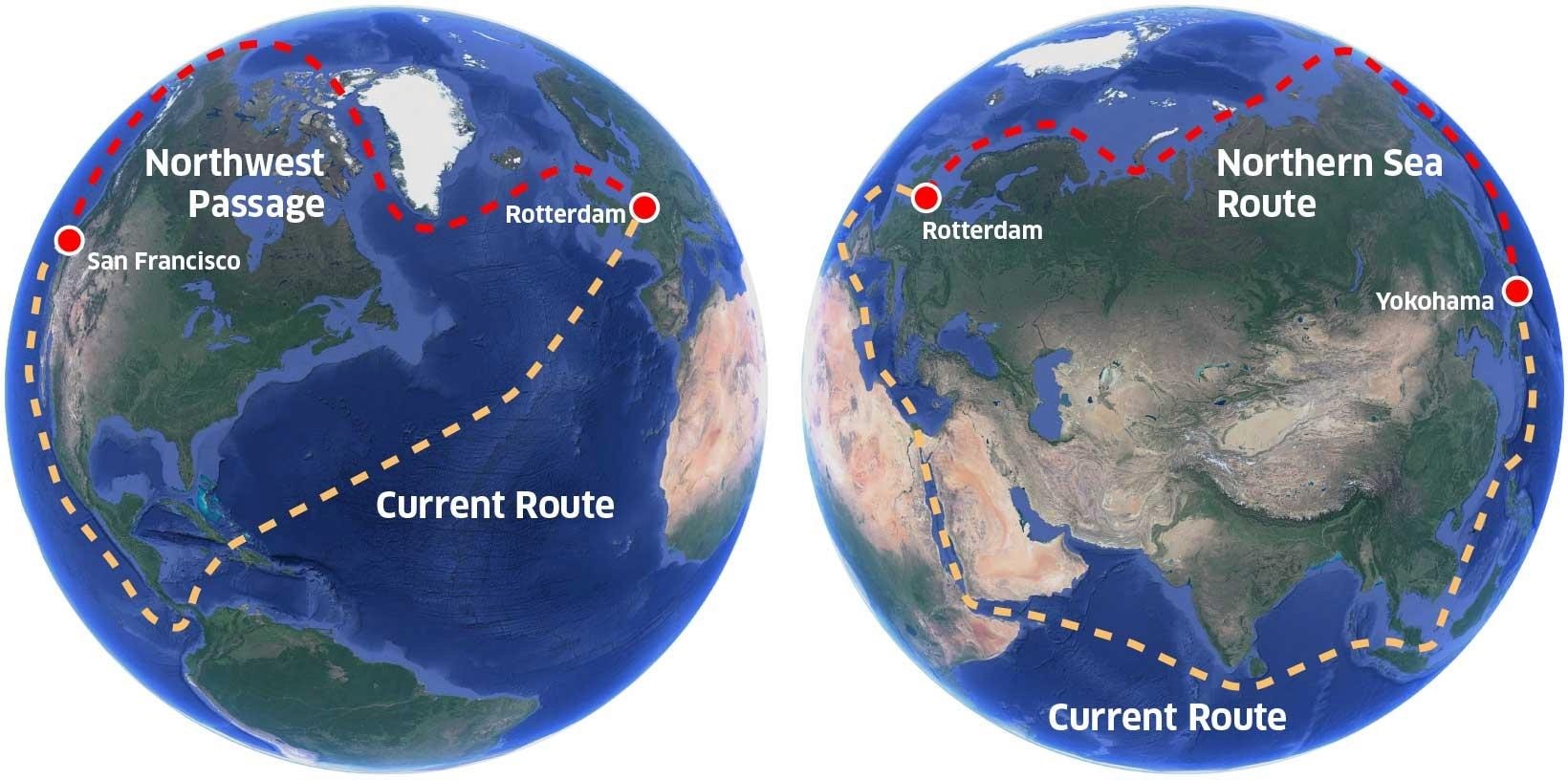
Interestingly, the majority of the existing literature concentrates on the comparison between the NSR and the SCR; the international shipping sector does not consider the NWP a viable option in the current situation, as explained in the previous section (Theocharis et al. 2018). The NWP’s comparisons with the PCR contain many hypotheses, especially regarding the climatic conditions, more specifically the opening period of the passage. The variables used in each study depend on the methodologies used. For example, it depends on the choice of analytical mathematical methods for transport cost models. Furthermore, different types of ships operate with different margins of profit. For instance, LNG carriers and container ships have different storage capacities. Nonetheless, the most important variables remain the same for all the comparisons, as shown in the figure below:
Figure 2: Variables for Shipping Cost Calculation (Raspotnik and Humpert 2016)
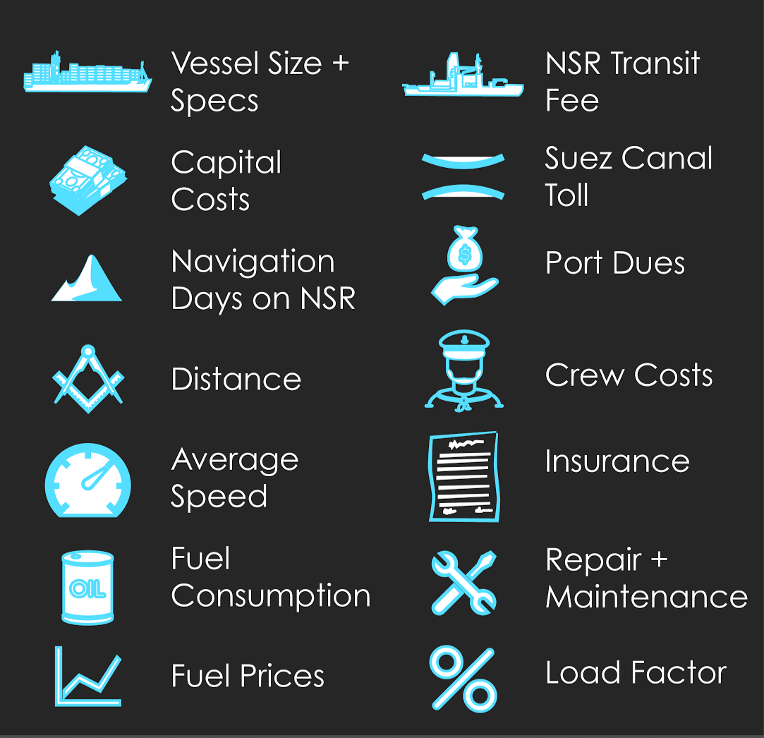
The most important variables are the distance, fuel cost and consumption, insurance, fees for the canal or the passage, the crew cost, the initial capital, and the speed. All of the above depend on the ship’s type. However, the cost of some variables is higher in the Arctic routes, irrespective of the ship. First, insurance for Arctic routes is more expensive due to higher uncertainty. The crew costs for the Arctic routes are also higher due to the harsh conditions and the need for additional training. Distance depends on the starting point and the final destination as illustrated in figure 3.
Figure 3: Sailing distances between Asia and Europe (Buixadé Farré et al. 2014)
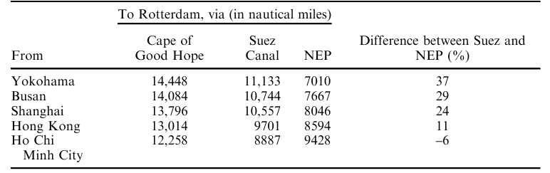
The NEP is shorter than the Cape route, irrespective of the starting port. Notably, some shipowners opt for the Cape route when there is much traffic in the SCR or the SCR is dangerous due to geopolitical reasons or piracy. The NEP is also safer because there is no piracy, although Russia’s geopolitics has detrimental consequences, mainly for Western companies and stakeholders. However, the NEP is shorter than the SCR only when the starting port is located from Hong Kong or further north. According to Lasserre, shipping to Yokohama is more cost-effective via both the NEP and the NWP (Lasserre 2015). The NWP is the shortest route between the Far East Asian ports and America’s East Coast. Although most simulations prove that the NWP is about 1000 nm shorter than PCR, the NWP becomes more profitable only under specific circumstances and in most simulations, it proves to be less profitable.
Another significant determinant is the fuel cost. Generally, higher fuel costs benefit the Arctic routes, particularly the NEP, where there are hydrocarbon facilities (Hansen et al. 2016, 42). Yet, the navigable season in the Arctic routes remains too short. It is important to mention that the ordinary fuel for ships is IFO 380, which is used in most simulations, but Arctic ships should use other kinds of fuel that are more ice-resistant, like the P50 (used by the Canadian Coast Guard) or F75 (Lasserre 2015, 240). These special fuels with lower freezing degrees cost more. Additionally, the average speed in the Arctic passages is lower than the Southern routes; sometimes, this may prove more economical depending on the transit’s cargo.
A ship adapted to the Polar Code requires more capital, rendering the Arctic even more expensive. Lasserre believes that the main problem of the Arctic routes is the load factor, meaning the ship’s cargo storage, and the transit speed, on which the ship’s rotation depends (Lasserre 2015, 258). The larger the load, the greater the economies of scale are. Meanwhile, more rotation opportunities give better cost optimization (port handling costs, fuel costs) and maximization of cargo capacity by expanding various destinations, often in specific regions or itineraries, like the Mediterranean and the Indian Ocean. The Arctic routes offer limited prospects in these domains and are generally used by a smaller quantity of ships. A ship company that uses the SCR can follow an interconnected network of ports and shipping lines, from the Yellow Sea to the Mediterranean and the Atlantic Ocean. The Arctic maritime infrastructure lacks these networks.
On top of that, the NSR and the NWP charge fees for icebreaking and monitoring coverage when necessary. The transits that use icebreakers are faster than the transits that do not, but the costs increase (Li et al. 2023). Unfortunately, the range of these fees is not stable. For example, the NSR’s administration has stated that fees are reduced for shipping companies that will use the passage regularly (Lasserre 2015, 251). According to Tschudi Shipping, NSR’s administration negotiates the tariff for each transit. On the other hand, the final toll of the Panama Canal and the Suez Canal also depends on the vessel’s size and type, as well as the cargo’s type. Thus, comparisons are extremely difficult to conduct in a real-world scenario.
Latest Developments in the NSR: A Look into the Future?
Recent developments in the NSR make evident the present interest of various stakeholders in this route and might reveal important insights for the route’s commercial future. During the summer of 2026, the first Arctic scheduled container transits started by the Chinese shipping company Sea Legend Line. The company scheduled seven ships on eight programmed transits between August and October (Shen 2026). Last year, it conducted its first testing sailing (The Maritime Executive 2026). This August, the South Korean vessel PanStar Acro began its first trial sailing using the NSR to sail to Europe and return to Busan, a South Korean port. The expected duration of the journey amounts to circa 40 - 45 days (Kim and Goh 2026). These sailings are exceptionally important, because the NSR is used as an Asia-European corridor and not as a destination or export shipping passage, as it usually is. Hitherto, the NSR is mainly a state-backed shipping route used to export hydrocarbons to Europe and Asia or transfer goods with the Arctic being the final destination.
The recent commercially driven endeavors may signal new prospects for the NSR, especially now due to the Strait of Hormuz crisis. At the same time, Putin declares the goal of extending the navigation in the NSR to year-round. To accomplish this, a new single regime will support the operations in the Arctic from 2027 to further expand the connectivity in the Russian Arctic and Far East regions (Teslova 2026). The same goal was also expressed by Rosatom (Russia’s nuclear state company), which builds new ice-class container ships and nuclear ice-breakers to achieve year-round navigation. According to Sergey Frank (Director General of Sovcomflot, Russia’s largest state-owned shipping company): “By 2028 - 2030, the transit interval for high ice-class vessels on the NSR could be reduced to 12 hours” (Rosatom Newsletter 2026). With Rosatom expecting an increase of 14% in cargo traffic this year (Interfax Information Group 2026), the commercial future of the NSR might have already started.
Conclusion
Based on the simulations, the current Arctic routes are not in a position to challenge the domination of the Southern maritime routes, purely on cost-effectiveness criteria. Their viability will depend on many factors, but the most important ones are the decrease in sea ice (and the corresponding increase in the navigability period), and infrastructure development. The NSR is more developed and has more potential to become a rival route to the SCR. Only the future can decide whether the Arctic passages will be able to compete with the traditional routes. However, most agree that only by the end of this century will the Arctic routes become a sustainable option for shipping companies as the passages will then be open all year round. In the meantime, these routes are used for geopolitical reasons. Namely, Russia uses the NSR to avoid international sanctions and naval blockades; China could do the same in the near future.
References
Buixadé Farré, Albert, Scott R. Stephenson, Linling Chen, et al. 2014. “Commercial Arctic Shipping through the Northeast Passage: Routes, Resources, Governance, Technology, and Infrastructure.” Polar Geography 37 (4): 298–324. https://doi.org/10.1080/1088937X.2014.965769.
Dean, Ryan. 2025. Comparing the Northwest Passage with the Northern Sea Route. NAADSN. https://www.naadsn.ca/wp-content/uploads/2025/05/25apr-Comaparing-the-NWP-with-the-NSR_RD-NAADSN-Policy-Brief.pdf
Gray, Bev. 2025. “Greenland, Panama, Canada & Russia’s Shipping Crisis.” Substack newsletter. Travel with Bev, February 13. https://travelguru.substack.com/p/greenland-panama-and-canada-the-global?utm_medium=web.
Hansen, Carsten Ørts, Peter Grønsedt, Christian Lindstrøm Graversen, and Christian Hendriksen. 2016. Arctic Shipping: Commercial Opportunities and Challenges. CBS Maritime. https://research.cbs.dk/en/publications/arctic-shipping-commercial-opportunities-and-challenges.
Interfax Information Group. 2026. “Rosatom Expects Cargo Traffic along Northern Sea Route to Rise 14% in 2026 - CEO.” September 1. https://interfax.com/newsroom/top-stories/118929/?utm_source=chatgpt.com.
Khon, V. C., I. I. Mokhov, M. Latif, V. A. Semenov, and W. Park. 2010. “Perspectives of Northern Sea Route and Northwest Passage in the Twenty-First Century.” Climatic Change 100 (3–4): 757–68. https://doi.org/10.1007/s10584-009-9683-2.
Kim, Jack, and Brenda Goh. 2026. “South Korea Ship to Test Arctic Commercial Route amid Western Concerns.” Reuters, August 22. https://www.reuters.com/world/china/south-korea-ship-test-arctic-commercial-route-amid-western-concerns-2026-08-22/.
Lasserre, Frédéric. 2015. “Simulations of Shipping along Arctic Routes: Comparison, Analysis and Economic Perspectives.” Polar Record 51 (3): 239–59. https://doi.org/10.1017/S0032247413000958.
Li, Zhiyuan, Li Ding, Luofeng Huang, et al. 2023. “Cost–Benefit Analysis of a Trans-Arctic Alternative Route to the Suez Canal: A Method Based on High-Fidelity Ship Performance, Weather, and Ice Forecast Models.” Journal of Marine Science and Engineering 11 (4): 4. https://doi.org/10.3390/jmse11040711.
Raspotnik, Andreas, and Malte Humpert. 2016. “Despite Global Warming Suez Canal Will Remain Preferred Shipping Route in Coming Decades New Study Suggests.” The Arctic Institute - Center for Circumpolar Security Studies, February 4. https://www.thearcticinstitute.org/despite-global-warming-suez-canal-will-remain-preferred-shipping-route/.
Rosatom Newsletter. 2026. “Rosatom Pushes for Year-Round NSR Operations.” May. https://rosatomnewsletter.com/2026/05/26/rosatom-pushes-for-year-round-nsr-operations/.
Shen, Cichen. 2026. “China’s Sea Legend Pushes Arctic Ambitions with First near-Weekly China-Europe Liner Service.” Lloyd’s List, July 16. https://www.lloydslist.com/LL1157867/China%E2%80%99s-Sea-Legend-pushes-Arctic-ambitions-with-first-near-weekly-China-Europe-liner-service?utm_source=chatgpt.com.
Teslova, Elena. 2026. “Putin Says Russia Planning Year-Round Navigation on Northern Sea Route.” Anadolu Ajansı, September 3. https://www.aa.com.tr/en/eurasia/putin-says-russia-planning-year-round-navigation-on-northern-sea-route/4046061.
The Maritime Executive. 2026. “China’s Sea Legend Poised to Launch First Regular “Ice Silk Road" Service.” August 10. https://maritime-executive.com/article/china-s-sea-legend-poised-to-launch-first-regular-ice-silk-road-service.
Theocharis, Dimitrios, Stephen Pettit, Vasco Sanchez Rodrigues, and Jane Haider. 2018. “Arctic Shipping: A Systematic Literature Review of Comparative Studies.” Journal of Transport Geography 69 (May): 112–28. https://doi.org/10.1016/j.jtrangeo.2018.04.010.
Zou, Leilei, and Shuolin Huang. 2015. “A Comparative Study of the Administration of the Canadian Northwest Passage and the Russian Northern Sea Route.” In Asian Countries and the Arctic Future, by Leiv Lunde, Jian Yang, and Iselin Stensdal. World Scientific. https://doi.org/10.1142/9789814644181_0008.
Theodor Skarvelis is an International Relations researcher specialising in geopolitics, geoeconomics, maritime strategy, and connectivity. He holds an MA in International Relations, Geopolitics and Connectivity from the University of Groningen and a BSc in International and European Economic Studies from the Athens University of Economics and Business. He has worked as Research Coordinator at the Institute of International Economic Relations and as Academic Assistant at Istanbul Kültür University. His research has addressed maritime sovereignty, Arctic geopolitics, strategic connectivity, and energy security. He has published in peer-reviewed outlets and presented research at international conferences. Currently, he is a Young Fellow at the European Group of Public Law.